Assabet River Trails
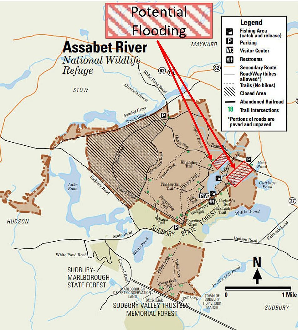
Alert: Potential Trail Closures Due to Flooding
Some trails at the refuge may be impassable due to flooding. Trail conditions are constantly changing due to a number of environmental factors. If you're planning a longer walk/hike, we advise you begin well before sunset to ensure you have enough time in case of a detour.
 File size: 605 KB
Download the trail and reference guide PDF
Things to Look Out For
- Bunkers and Railbeds: Ammunition bunkers from WW II and their railbeds Remnantsare nestled in the forest.
- Puffer Pond: Herons and Kingfishers can often be seen at the edges of the pond. Native American dugout canoes are still slumbering at the bottom of the pond never having been retrieved after they were sunk for winter storage.
- Beaver Activity: Look out for the past activity of beavers cutting down trees!
- Old Homesteads: The remains of chimneys and field walls dot the landscape. George Washington is said to have visited the Rice Tavern the remains of which can be seen near the intersection of Taylor and Winterberry Ways.
Trails
Trail name links below open the interactive map on the National Wildlife Refuge website.
North Section
- Petapawag Trail (0.85 miles)
This was a railroad trunk line during World War II. It is adjacent to a laser beam course used by the Air Force. - Harry’s Way (1.82 miles)
- Towhee Trail (0.97 miles)
This area was the Henry Ford Farm. Before Henry Ford bought it in 1928, it was known as the Gately Farm. This is a Red-tail Hawk nesting area. - Hill Trail (0.38 miles)
- Powerline Trail (0.23 miles)
This road was originally Old Marlboro/Concord Road. During the war of Independence in 1776, ammunition wagon trains traveled this road to deliver arms to George Washington used to defend Trenton. Minutemen used this road to travel to the battle of Concord and Lexington. - Winterberry Way (1.46 miles)
- Patrol Road (0.79 miles)
- White Pond Rd (1.45 miles)
- Carbary’s Trail (0.11 miles)
This trail once called the Lakeshore Drive and the land called the Arrow Head Estate because of the shape of Puffer Pond. The land belonged to the Reilly’s and was also known as the Reilly Estate. - Tri-Town Trail (1.24 miles)
This trail serviced the most of the 50 bunkers built in 1942. There is an old railroad “Guard Shack” near the intersection of Tri-Town Trail and Pine Garden Trail. - Otter Alley (0.35 miles)
This trail borders what were once the Anderson Family Farm as well as the Puffer’s farm. The Puffers moved here in 1743 and renamed the Pratt Pond as Puffer Pond. There are cranberry bogs in the area and otter trails “crossing” in the area. - Kingfisher Trail (0.09 miles)
The Finnish Ice House was located here. In the early part of the 1900’s there was a thriving Finnish community in Maynard who had arrived to work in the Woolen Mills. Ice was cut from the pond for Finnish families who used it to keep their food fresh. This land belonged to a member of the Anderson Family, who built a honeymoon cottage. There was once a private beach there. There are several tall pines in the area where Ospreys and Great Blue Heron’s nests. - Pine Garden Trail (0.31 miles)
The boundary of the three neighboring towns, Stow, Sudbury and Maynard meet at the intersection of the Pine Garden Trail and Tri-Town Trail. - Puffer Pond Trail (0.42 miles)
- Tebassa Trail (0.1 miles)
- Taylor Way (1.8 miles)
- Sandbank Trail (0.1 miles)
South Section
These trails are part of the “Classification yard” where train cars are held that services the ammunition holding area.
- Fisher Loop (2.35 miles)
The area near the start of Fisher Loop is believed to be haunted by a “four-horse team”. Many people think they can hear horses galloping. This trail is behind what was the Raytheon building. The three towns of Marlboro, Hudson and Sudbury have their boundaries intersect here. This also where the train track of the Mass Central line comes through Sudbury. This is why the US Government chose the location and bought the land for the ammunitions depot in 1940. - Mink Link (0.14 miles)
- Sweet Fern Trail (0.29 miles)